Photo of Scott L. Shapiro

Scott Shapiro is known for his expertise in flood protection improvement projects throughout California’s Central Valley. He is helping clients with more than a billion dollars in projects in California's Central Valley and issues involving the Federal Emergency Management Agency (FEMA) and the U.S. Army Corps of Engineers (USACE) throughout the Western United States.

With a special focus on massive flood protection improvement projects, Scott advises clients through regulatory, contractual, financing, and legislative challenges. Acting as general or special counsel, he regularly interacts with senior management at USACE (Headquarters, South Pacific Division, and Sacramento District), the California Department of Water Resources, and the Central Valley Flood Protection Board. He was named to the National Section 408 Task Force and has been invited to give testimony to the National Academies. Scott was instrumental in helping the first regional flood improvement agency that took a basin threatened by flood risk from less than 30-year level of protection to a level of protection approaching 200-year.

Having worked with FEMA on issues of floodplain mapping and levee accreditation for many years, Scott has developed collaborative environments in which he fosters win-win solutions for his clients. He is also currently serving as the lead counsel on a flood insurance rate map (FIRM) appeal and has drafted Federal legislation to modify the National Flood Insurance Program (NFIP) several times.

Scott is known throughout the region for his extensive litigation experience focusing on cases arising from levee failures. He has litigated levee failures resulting from underseepage, failed encroachments, and rodent burrows as well as briefing levee overtopping cases at the appellate level. Scott is one of the few attorneys with experience litigating flood cases on behalf of plaintiffs as well as defendant government entities.

Bags of crushed rock ready to be dropped into damaged areas of Spillway. Dale Kasler/The Sacramento Bee
Bags of crushed rock ready to be dropped into damaged areas of Oroville Dam emergency spillway. Dale Kasler/The Sacramento Bee

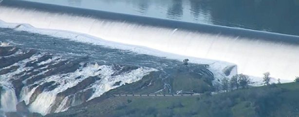
Here is Wednesday morning’s installment of our update on the Oroville Dam spillway incident and more news about the valley. For background, please see our earlier blog posts which set the stage and provide context.  In sum, the mandatory evacuation is over; the emergency or auxiliary spillway remains stable; workers continue to add rock and concrete to address the erosion that led to the evacuations; the primary or service spillway is also stable, and is still evacuating 100,000 cfs from the reservoir; but new storms are forecasted to roll in starting Wednesday evening.

Because there is less news today, we have tried to provide some information on the weather and flood system operations.  As always, if you find this blog helpful or interesting, please feel free to share it with others who may be interested. And if you would like to be updated when we post a new entry, please add your email on the right where it says “stay connected.”

Oroville Emergency SpillwayHere is Tuesday morning’s installment of our update on the Oroville Dam spillway incident.  For background, please see our earlier blog posts, starting last Thursday, February 9, and most recently our update of February 13 which sets the stage and provides context.  In sum, the evacuation continues; the emergency or auxiliary spillway is stable; workers are adding rock to address the erosion that caused the evacuation; the primary or service spillway is also stable, and is currently evacuating 100,000 cfs from the reservoir; but new storms are forecasted to roll in starting Wednesday, and many people are still worried about how the reservoir and its spillways will handle the water.

Once again we have tried to share the important facts and the context, without hype, sensationalism, or blame.  If you find this helpful, please feel free to share it with others who may be interested.  And if you would like to be updated when we post a new entry, please add your email on the right where it says “stay connected.”

On Saturday we said, “What a difference a day makes!”  And that is true again!  As of Sunday night at 11:00 pm when we wrote this we had been through several very scary hours and over a hundred thousand people had been evacuated from their homes.  Indeed, the facts are so fluid and the information so incomplete that we debated not posting at all.  But we ultimately decided to post what we know, again in a simple format to hopefully make it easily understandable for those trying to follow along.  But remember, there is always a risk that by the time you read this, it may be out of date.

Oroville SpillwayWhat a difference a day makes!  As of Friday afternoon, it appeared unlikely that Oroville Reservoir would rise enough for water to flow over the emergency spillway, as inflow into the lake had been declining since early Friday, the rain had stopped, and the primary spillway continued to be used to manage outflow. But the gaping hole in the spillway, coupled with concerns about downstream flooding, resulted in the story traveling all the way back to New York.  And with the latest inflow figures and DWR’s modified release schedule from the Primary Spillway, the emergency spillway actually started spilling on Saturday morning.

The Oroville DamAs many of you know, the big news on Tuesday was that the spillway on Oroville Dam had developed a large crater from water eroding away the Oroville Spillway structure.  Based on the large hole, DWR stopped all flows down the Spillway to evaluate the damage.  Water users downstream started to get nervous as Oroville was rising quickly, and folks feared that water could come over the emergency spillway, which would be uncontrolled.

So this might be time to back-up and offer some context.  Oroville is on the Feather River and holds about 3.5 million acre-feet.  It was about 80% full when this happened, and the operators were releasing about 70,000 cfs to make room for the storm that was on its way in.  Inflow into Oroville has exceeded 200,00 cfs in the past, and the levees downstream have historically started to be stressed at flows approaching the 100-year event, or about 150,000 cfs.  Thus, the strategy was to release enough water to make room to hold back the peak of the latest storm.  In other words, the reservoir was to function as intended.

ThoughtsThis is a follow-up to our blog post last week, “FEMA Issues Draft Regulatory Amendments To Implement President Obama’s Executive Order 13690 And The Federal Flood Risk Management Standard; Comments Due By October 21, 2016.”

FEMA’s Approach to Amending Its Regulations

Many of the proposed amendments to the regulations focus on the details for the implementation methodologies as well as the inter-relationship between them. For example, what should one do when there are contradictory scientific approaches? What should one do when the best available science indicates a flood elevation that is lower than would be used under the freeboard value approach? Is it practical to use the .2 percentage approach when only 18% of FEMA’s maps contain data on the .2% event? Based on these and other questions, on page 35 of the proposed amendment package FEMA proposes to make the freeboard value approach the standard approach for all events that are not critical actions, and to make the freeboard value approach the chosen approach for critical actions unless the agency finds that the climate-informed science approach results in a higher elevation.

EightIntroduction

Executive Order 11988 (EO 11988) requires Federal agencies to avoid, to the extent possible, the long- and short-term adverse impacts associated with the occupancy and modification of floodplains where there is a practicable alternative. The Federal Emergency Management Agency (FEMA) is now proposing to amend its regulations (found in 44 CFR Part 9) which describes the traditional 8-step process that FEMA uses to implement EO 11988. The amendment is being driven by Executive Order 13690 (EO 13690), issued by President Obama in 2015 to address increased risks as a result of climate change, which changed the definition of “floodplain” for projects that are “Federally funded” (defined as actions involving the use of Federal funds for new construction, substantial improvement, or to address substantial damage to a structure or facility). In these cases, the new broader definition of floodplain (developed under one of three approaches described below) will likely result in a larger floodplain and a requirement to design projects such that they are resilient to a higher vertical elevation. However, for actions that don’t meet the definition of a Federally funded project, FEMA will continue to use the historical definition.

5 DucksIntroduction

The Senate’s Water Resources Development Act (WRDA – S.2848) would reduce the deficit by $6 million in its first decade, the Congressional Budget Office has said. This score makes it more likely that the bill may get floor time, although the very limited number of Congressional sessions between now and the election makes passage of the bill increasingly unlikely.

Discussion

WRDA is the act by which Congress authorizes new water resources projects, including new ports, locks and levee projects while also advancing improvements to the country’s municipal water programs. Once upon a time, WRDA was passed about every two years, but starting in the late 80’s the time between acts started slipping, culminating in acts in 2000, 2007, and 2014. The Republican leadership, in particular Congressman Schuster in the House, has been pushing to pass a bill this year, returning Congress to its every other year schedule. Supporting this effort is a series of Chief’s Reports that have been finalized, a necessary precursor to the U.S. Army Corps of Engineers advancing flood risk reduction and ecosystem restoration projects.

The Congressional Budget Office (CBO) scores bills based on their costs to the nation. The lower the score, the less costs, and the more likely that the act will receive floor time in light of the Majority’s PayGo (“pay as you go”) philosophy. The CBO has concluded that the Senate bill would cost $10.6 billion overall in its first decade. But because those are just authorizations, Congress would still need to appropriate funds.

Flood Insurance. ProgramjpgPeople definitely care. But not enough people are likely to care to make a political issue out of it due to how the rate increases were designed. The National Flood Insurance Program (NFIP) rate increases called for by the last two acts of Congress are designed as slow and modest increases for the vast majority of folks holding policies. Indeed, this appears to be the reason Congress passed the Homeowner Flood Insurance Affordability Act of 2014 (HFIAA), in order to amend and soften the rate increases called for by the Biggert-Waters Flood Insurance Reform Act of 2012. During this current election year it takes a lot to get Congress focused on action, and the rate increases do not appear to fall on a large enough group to generate the noise that gets Congress’ attention. Added to that, the Republican Party is currently focused on demonstrating fiscal restraint, and rate increases designed to repay an approximately $20 billion deficit fit right into the current messaging.

I think that the following headline would have gotten the attention of people and politicians and possibly caused Congress to change its mind: “NFIP rates for homes to grow more than 20% a year!” However, that is only a true statement for non-primary residences located in AE and VE zones that were constructed before the first NFIP flood insurance rate map (FIRM) issued for the relevant region (so called “pre-FIRM” structures). A pretty small group of folks would be affected by this. Or perhaps a headline like: “25% annual rate increases by FEMA will apply to businesses!” But that is only a true statement for businesses located in AE and VE zones that were also constructed before the first NFIP flood insurance rate map issued for the relevant region. Again, a small group of folks to lobby Congress.