Clark Bypass cropped
The Sutter Bypass looking north; photo by Andrea Clark

It feels like Monday morning’s installment should start with a rousing round of “rain, rain, go away, come again another day, Californians want to play!”  With even more storms set to hit Northern and Southern California, the rain totals continue to rise and Mother Nature once again shows her awesome power.  Today’s installment is focused on short summaries of events from around the state.

As always, if you find this blog helpful or interesting, please feel free to share it with others who may be interested. And if you would like to be updated when we post a new entry, please add your email on the right or below where it says “stay connected.”

Power Transmission Towers

Here is Saturday morning’s installment of our update on the Oroville Dam spillway incident and more news about the valley.  In summary, Oroville’s Powerhouse is still not able to produce power; the emergency or auxiliary spillway remains stable; workers continue to add rock and concrete to address the erosion that led to the evacuations; the primary or service spillway is also stable, and is now  evacuating 70,000 cfs from the reservoir; but new storms have started to roll in.

As always, if you find this blog helpful or interesting, please feel free to share it with others who may be interested. And if you would like to be updated when we post a new entry, please add your email on the right or below where it says “stay connected.”

Bags of crushed rock ready to be dropped into damaged areas of Spillway. Dale Kasler/The Sacramento Bee
Bags of crushed rock ready to be dropped into damaged areas of Oroville Dam emergency spillway. Dale Kasler/The Sacramento Bee

Here is Wednesday morning’s installment of our update on the Oroville Dam spillway incident and more news about the valley. For background, please see our earlier blog posts which set the stage and provide context.  In sum, the mandatory evacuation is over; the emergency or auxiliary spillway remains stable; workers continue to add rock and concrete to address the erosion that led to the evacuations; the primary or service spillway is also stable, and is still evacuating 100,000 cfs from the reservoir; but new storms are forecasted to roll in starting Wednesday evening.

Because there is less news today, we have tried to provide some information on the weather and flood system operations.  As always, if you find this blog helpful or interesting, please feel free to share it with others who may be interested. And if you would like to be updated when we post a new entry, please add your email on the right where it says “stay connected.”

Oroville Emergency SpillwayHere is Tuesday morning’s installment of our update on the Oroville Dam spillway incident.  For background, please see our earlier blog posts, starting last Thursday, February 9, and most recently our update of February 13 which sets the stage and provides context.  In sum, the evacuation continues; the emergency or auxiliary spillway is stable; workers are adding rock to address the erosion that caused the evacuation; the primary or service spillway is also stable, and is currently evacuating 100,000 cfs from the reservoir; but new storms are forecasted to roll in starting Wednesday, and many people are still worried about how the reservoir and its spillways will handle the water.

Once again we have tried to share the important facts and the context, without hype, sensationalism, or blame.  If you find this helpful, please feel free to share it with others who may be interested.  And if you would like to be updated when we post a new entry, please add your email on the right where it says “stay connected.”

On Saturday we said, “What a difference a day makes!”  And that is true again!  As of Sunday night at 11:00 pm when we wrote this we had been through several very scary hours and over a hundred thousand people had been evacuated from their homes.  Indeed, the facts are so fluid and the information so incomplete that we debated not posting at all.  But we ultimately decided to post what we know, again in a simple format to hopefully make it easily understandable for those trying to follow along.  But remember, there is always a risk that by the time you read this, it may be out of date.

Oroville Spillway
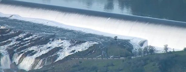
What a difference a day makes!  As of Friday afternoon, it appeared unlikely that Oroville Reservoir would rise enough for water to flow over the emergency spillway, as inflow into the lake had been declining since early Friday, the rain had stopped, and the primary spillway continued to be used to manage outflow. But the gaping hole in the spillway, coupled with concerns about downstream flooding, resulted in the story traveling all the way back to New York.  And with the latest inflow figures and DWR’s modified release schedule from the Primary Spillway, the emergency spillway actually started spilling on Saturday morning.

The Oroville DamAs many of you know, the big news on Tuesday was that the spillway on Oroville Dam had developed a large crater from water eroding away the Oroville Spillway structure.  Based on the large hole, DWR stopped all flows down the Spillway to evaluate the damage.  Water users downstream started to get nervous as Oroville was rising quickly, and folks feared that water could come over the emergency spillway, which would be uncontrolled.

So this might be time to back-up and offer some context.  Oroville is on the Feather River and holds about 3.5 million acre-feet.  It was about 80% full when this happened, and the operators were releasing about 70,000 cfs to make room for the storm that was on its way in.  Inflow into Oroville has exceeded 200,00 cfs in the past, and the levees downstream have historically started to be stressed at flows approaching the 100-year event, or about 150,000 cfs.  Thus, the strategy was to release enough water to make room to hold back the peak of the latest storm.  In other words, the reservoir was to function as intended.

Most flood control projects require environmental review triggered by a federal, state, or local agency permit or decision. For example, federal agencies must consider the environmental impacts of their proposed actions under the National Environmental Policy Act (NEPA), and many states have their own “mini-NEPA” laws that require state and

A lawsuit brought in 2013 by the Southeast Louisiana Flood Protection Authority-East has been dismissed by a federal judge who found that the Authority had failed to support its claims against dozens of oil, gas and pipeline companies. The Authority sued the companies for damages, arguing that their oil and gas exploration activities had damaged wetland areas, making the coast more vulnerable to flooding during hurricane events such as Hurricane Katrina in 2005.

Background

The Southeast Louisiana Flood Protection Authority-East (Authority) is one of two levee authorities that service the metropolitan New Orleans area. The authorities are responsible for protecting residents, businesses and properties from flooding, including adopting rules and regulations for carrying into effect a comprehensive levee system (which includes levees, floodwalls, drainage structures and floodgates).

In July 2013, the Authority filed suit against 97 oil, gas and pipeline companies on the theory that their exploratory activities over time have damaged wetlands, which in turn has left New Orleans vulnerable to catastrophic flooding. Specifically, the suit alleges that the dredging of canals by the oil and gas companies allowed for destruction of wetlands that protect the New Orleans area from flood damages, and that those damages complicated and increased the cost of management of the levee system.